
Data-driven infographic exploring the Australian aviation wildlife strike statistics dataset from the Australian Transport Safety Bureau
-
 View project‘Waste World’ is a multi-dimensional globe visualization that shows how the layer of the world looks like if we compare countries by their waste generation… The Globe: The height of the country...
 -
 View projectThis interactive narrative aims to illustrate the contrasting disparities in the lives and opportunities of children in Eastern and Western Europe, using the metaphor of children's books. Not all...
 -
 View projectthe placement of cctv cameras in the college campus and how many cases are solved through it. Data of solved, unsolved and total cases as well as the types of camera used in the campus and their...
 -
 View projectThis installation explores the complexity of the UK food system by highlighting the horticultural decline in home-grown fruit and the reliance on imports. The project is inspired by the purchase...
 -
 View projectSince the nuclear accident caused by a powerful earthquake in 2011, Japan has been storing a huge amount of contaminated wastewater in the Fukushima Daiichi Nuclear Power Plant. Now that it almost...
 -
 View projectThe project attempts to understand the water consumption in the Design hostels. The data was collected with the help of the warden of the hostels and the plumbers who maintain the same. The...
 -
 View projectThis infographic shows the layout of the gym and all the equipment placed inside. The equipment are categorized by three categories: Leg, arm and ab workouts. Secondly, the registration process and...
 -
 View projectWith Climate Change, my country Portugal has been witnessing a drastic worsening of its water supply. Severe droughts have been decimating up to 90% of the territory over the past years. Besides...
 -
 View projectThis visualization represents the correlations between the 10 key factors in the smart city rankings published by Eden Strategy Institute in their Top 50 Smart City Government Ranking 2020/2021...
 -
 View projectA just transition to a net zero world needs to be inclusive. In this visualization, we explore equity and equality, the relationship between wealth and CO2 emissions, and the impacts of climate...
 -
 View projectI did a survey and observed cycles in and around my college campus based on their condition if they are geared or non-geared, where they are located, whether they are locked or not and much more....
 -
 View projectThis infographic charts the 3 highest mountains on each of the seven continents across the world. The visualization shows isometric illustration of the 1st highest of all the continents, and uses...
 -
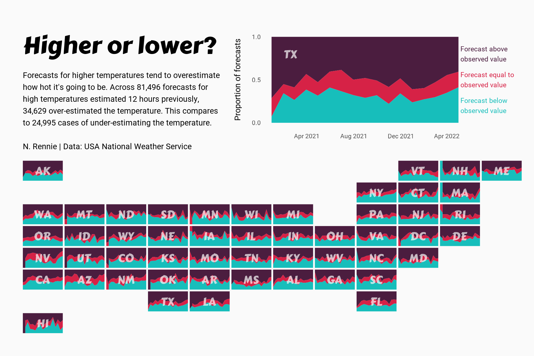
 View projectThis chart visualises the accuracy of high temperature forecasts made by the USA National Weather Service between January 2021 and June 2022, within a 12 hour window. Proportional area charts show...
 -
 View projectA multi-angle analysis of the 2022 UK housing market, which breaks the (positively-skewed) dataset into quartile groups based on house price with a top outliers group for the stately homes and...
 -
 View projectHot air balloon model by LowPolyBenjamin from CGTrader. Video: https://youtu.be/4rNZxua2_qE #MapboxGL #MapTiler #ThreeJS #WebGL #3D #maps #buildings #hotair #balloons #fly #nyc #manhattan...
 -
 View projectThe project is inspired by Wabi-Sabi- a philosophy from Zen Buddhism which centres on the belief that showing truth comes from observing nature. The approach sees and celebrates the beauty of the...
 -
 View projectWe commemorate 150th anniversary of the unification of Buda, Pest and Óbuda into Budapest with a series of 50 alternative maps, mainly produced from open source or publicly available data. The maps...
 -
 View projectThe project comprises a publicly accessible, interactive webmap, aimed to communicate the rise and fall of London’s Low Traffic Neighbourhoods (LTNs) temporally over the course of the 2 year COVID...