
Climate change has a direct impact on the intensity and frequency of heavy rainfall and heat waves. This is shown by the IPCC reports from 2021. The interactive data story “Weather Extreme”...
-
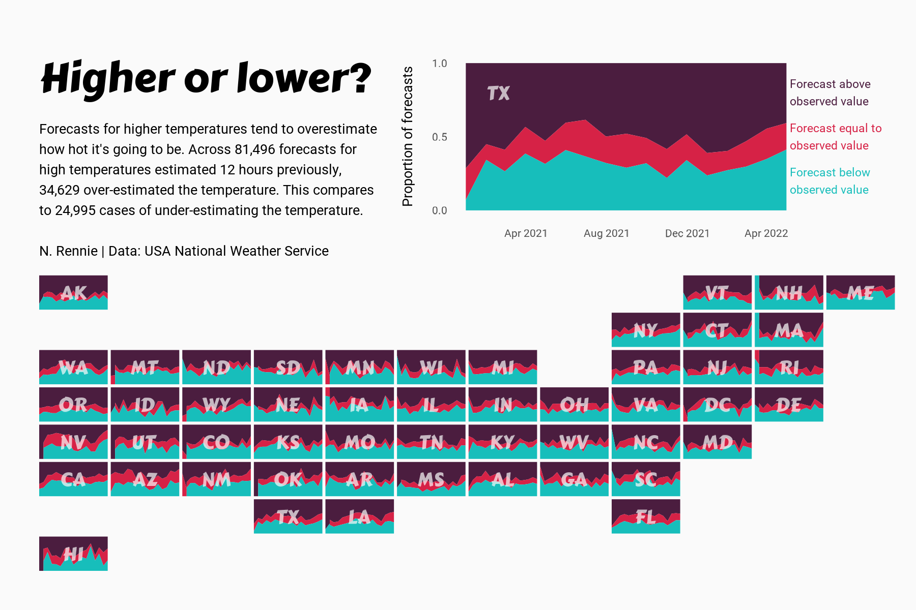
 View projectThis chart visualises the accuracy of high temperature forecasts made by the USA National Weather Service between January 2021 and June 2022, within a 12 hour window. Proportional area charts show...
 -
 View projectVisualizing the 2016 metric tons of coffee produced and the coffee belt between the tropics of cancer and capricorn.
 -
 View projectA creative and experimental map-like visualisation crafted for cheese and wine lovers. Depiction of the principal vineyard regions in Metropolitan France as red wine spills fallen on a...
 -
 View projectNational Hurricane Center data for Miami, Washington, D.C., and New York City show development happening in at-risk areas, even as climate change brings more frequent and intense storms. This story...
 -
 View projectThe impact of internet use on the environment is a contradictory topic. This impact differs according to the reduction/increase of carbon emissions that end up affecting the environment. For...
 -
 View projectCCUSA provides disaster relief assistance and wanted to create a map to better target mitigation, preparedness, relief, and recovery projects in order to best serve communities that are both at...
 -
 View projectThe Shrinking Lakes cross-border investigation was reported by 12 journalists from the InfoNile network in Uganda, Kenya, Tanzania, and Rwanda over a year and a half. It contains original data...
 -
 View projectDear Judges: More than six million people visited the Grand Canyon National Park in 2018. In 2019 people kept coming, undeterred by the three deaths in the first three months of the year. Since...
 -
 View projectLiaoning province has six world cultural heritage sites, of which the Manchus occupy four: Qingfu Mausoleum, Shenyang Imperial Palace, Qingzhao Mausoleum and Qingyong Mausoleum. Due to the lack of...
 -
 View projectWhile Canada is well-known for its winters, it is also home to deadly urban heat waves. But where are the areas most affected by extreme heat? And who lives in them? Answering these simple...
 -
 View projectOur methodology, termed as "streetonomics", is a form of computational social science that studies human behavior and cultural trends through the quantitative analysis of street...
 -
 View projectThe first high speed train connected the cities of Tokyo and Osaka in a train circulating at 200km/h. This visualisation takes a look at how the Tokaido Line has evolved.
 -
 View projectWater stress or scarcity does always need to be reflected in context. While some parts of the world are only sparsely populated, the impact and mitigation of water stress in densely populated areas...
 -
 View projectThe Mercator projection map tends to be what most of us think of when pondering the world map. However, it has a major flaw, since it drastically distorts the size of objects approaching the poles....
 -
 View projectModum is a series of large format canvases that explore the rhythm of commercial activity. By plotting scraped business location data, a new kind of data landscape is created: a self portrait of a...
 -
 View projectIndia's pursuit of economic growth to improve citizens' quality of life presents a challenge in balancing development with environmental sustainability. Navigating the socio-cultural and economic...
 -
 View projectClimate change has had catastrophic effects on California’s forests, but the proposed solutions to protect them have ignored certain voices. This infographic shows how rising temperatures have...
 -
 View projectThe issue of segregation of immigrants has generated a lot of interest in many Western countries, not least in Sweden in the run up to the 2018 elections. In the midst of many alarmist stories...
 -
 View projectTomTom is the only independent mapmaker in the world today, and has been making maps for the world’s largest technology companies, car manufacturers, fleet management organizations, city...
 -
 View projectThe Minimum Fleet Network model proposes efficient vehicle-trip assignments that reduce the empty time between trips with a passenger onboard. This way, a taxi can serve more passengers in the same...
 -
 View projectCityWays is research at MIT Senseable City Lab to reveal human’s recreational patterns through visualizing datasets from self-tracking applications and environmental factors. In the CityWays web...
 -
 View projectRoad kills often occur at night when vision is less clear.I imagined the desperate eyes of animals lying on the road after being hit by a car.Design with the shape of the pupil.Pupils shrink when...
 -
 View projectThis infographic reveals the 20 most congested cities in the world, measured by the increase in travel times compared to the free flow of traffic
 -
 View projectWhat aspects of our modern life can be found at any place and in any scale? A neighborhood, city, and region are analyzed by uniformly displaying selected data in the same four fields: Economy,...


