
Woman-man: a fair duel? For your salary difference, test the 2016 edition of Pariteur, the only application based on all French wages.
-
 View projectThe real estate market has been one of the main driving forces of China’s economy for more than one decade. This fast growing industry also contributed to social inequality in urban...
 -
 View project‘How cities are governed’ is an interactive visualisation which presents the results of the global Urban Governance Survey undertaken by LSE Cities in partnership with UN Habitat and UCLG...
 -
 View projectGhost Waste is an interactive installation to attract and to make people familiarize with the problems of ecomafia in an easy way. The observer can thus ‘physically touch’ the problem, activating...
 -
 View projectThis design is one of my course assignments, according to the computer query some information about the recycling of materials, analyzed and simplified, combined with some illustrations design...
 -
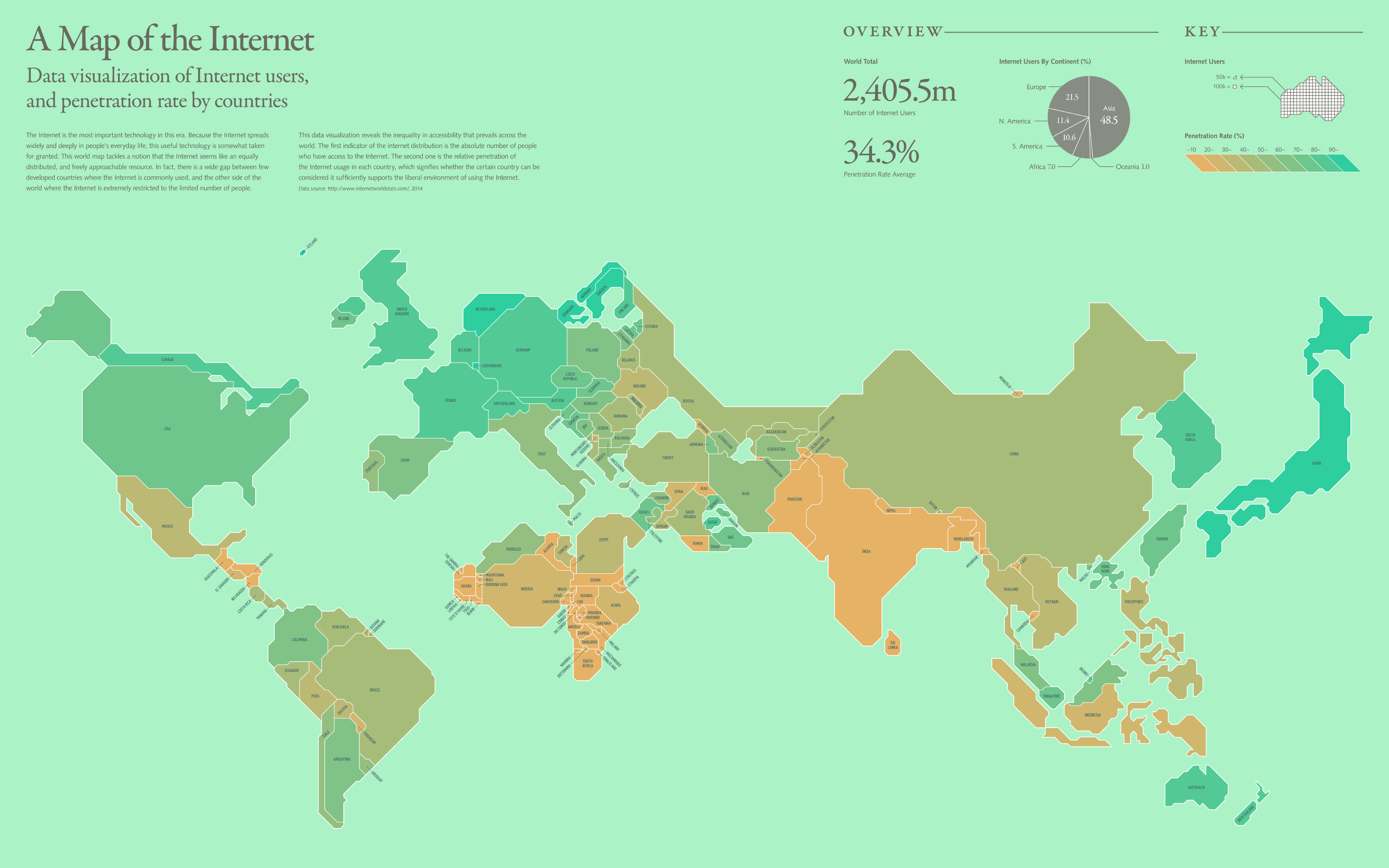
 View projectThe Internet is the most important technology in this era. Because the Internet spreads widely and deeply in people's everyday life, this useful technology is somewhat taken for granted. This world...
 -
 View projectExplore your favourite “based on a true story” films scene-by-scene, beat-by-beat and test their veracity on a data level. Obviously watch out – **MEGA SPOILERS**
 -
 View projectAs climate change alters habitats and disrupts ecosystems, where will animals move to survive? And will human development prevent them from getting there? This map shows the average...
 -
 View projectThe project investigates the problem of air pollution in modern megapolices. The main purpose was to tell about the influence of different urban systems on environment, their correlation and role...
 -
 View projectcf. city flows is a comparative visualization of urban bike mobility designed to help citizens casually analyze bike-sharing systems in the context of a public exhibition space. Three...
 -
 View projectXavi Bou focuses on birds, his great passion, in order to capture in a single time frame, the shapes they generate when flying, making visible the invisible. Unlike other motion analysis...
 -
 View projectEniday is an Eni’s project, a digital magazine focused on innovation and storytelling, providing explainations and stories on how natural resources are transformed into energy. The Visual Agency...
 -
 View projectHow to read this chart: Each line chart shows the rate of change since 2009 of tuition and fees in US states (counting public in-state four year institutions). Red shows values higher than the...
 -
 View projectAn explorable 3D landscape built using data from an analysis of Grimm's folktales. I identified words in the stories that stood out against common English and used this to generate a landscape on...
 -
 View projectThese animated virus trading cards show the real 3D structure of viruses. Using scientifically accurate structure data from the Worldwide Protein Databank, each trading card reveals the viral...
 -
 View projectInteractive neural network widget visualises outcomes of machine learning according to different parameters.
 -
 View projectThe visualization shows the meals described in 49 novels. The descriptions and the novels have been selected by Dinah Fried, who has collected them in the book Fictitious Dishes: An Album of...
 -
 View projectThis poignant infographic offers an overview of the roots of racism through the centuries, trying to expose the causes of this modern scourge.
 -
 View projectMusicmap tries to provide the ultimate genealogy of all popular music genres and bundles any information regarding music genres and history in one dynamic map, serving as both an educational tool...
 -
 View projectThis was a semester long project that was created during my studies at Fachhochschule Nordwestschweiz FHNW in Basel, Switzerland. This project shows the impacts trough deforestation. From the...
 -
 View projectHow old are you? How old were the great and the good when they peaked, or got their big break? WHO old are you?
 -
 View projectTimescapes is a series of photographs and videos that document the patterns and algorithms that define places. This project uses "slit-scanning," wherein a photo medium is exposed in a single...
 -
 View projectSmoke and Fire is an interactive visualisation of air pollution in Australia, particularly shipping plume along the east coast of New South Wales. The aim was to present the data to experts as...
 -
 View projectThe Toronto Symphony Orchestra’s ‘listening guides’ make use of symbols and morse code-like notation to aid the experience of a live performance.
 -
 View projectThis text is designed to accompany your study of introductory digital signal processing. It’s an eccentric piece of not-so-rigorous literature with a preoccupation for explaining things using...
 -
 View projectThe double-sided information graphics for the magazine Hochparterre illustrates figures on Swiss preservation of historical monuments: job percentages of specialist departments on cantonal and city...


