
San Diego is California's second largest city, and offers beautiful beaches, world-class attractions, and plenty of outdoor activities. Explore some of the most popular attractions in this vintage...
-
 View projectA map of Senja, Lofoten & Vesterålen with touches of personal data to remember the five months I traveled through Norway in 2022 with my partner. I loved the whole country, but these locations...
 -
 View projectI decided to visualize the largest lakes around Berlin using a new technique in Illustrator. This was a fun project to familiarize myself with my new living area and practicing the language while...
 -
 View projectThe Infographic show important details about the mess in the university campus for the students.
 -
 View projectThis project is part of a permanent exhibition at Fondazione Pistoletto (Biella) and was created in collaboration with some local organizations. The theme is water: from the laws that regulate...
 -
 View projectIntroducing "Carbon Emission of the World," a captivating Tableau dashboard designed to shed light on the pressing issue of carbon emissions. This visually compelling and informative report offers...
 -
 View projectWith Climate Change, my country Portugal has been witnessing a drastic worsening of its water supply. Severe droughts have been decimating up to 90% of the territory over the past years. Besides...
 -
 View projectThe in-house bakery makes hundreds of bakery products each day for the students to consume them but a lot of people do know about it. This data helps to understand the different products produced...
 -
 View projectThe UNICEF Global Database on School-Age Digital Connectivity tracks the percentage of children 3 to 17 who have internet connectivity at home. The United Kingdom has the highest percentage at...
 -
 View projectClimate change has had catastrophic effects on California’s forests, but the proposed solutions to protect them have ignored certain voices. This infographic shows how rising temperatures have...
 -
 View projectThe project comprises a publicly accessible, interactive webmap, aimed to communicate the rise and fall of London’s Low Traffic Neighbourhoods (LTNs) temporally over the course of the 2 year COVID...
 -
 View projectTrading the Fragile: An Insight into the CITES and IUCN databases is a data-driven project aiming to shed light on the work of these two organizations. By highlighting the most traded species...
 -
 View projectRuas do Género: Exploring Gender Representation in Urban Toponymy "Ruas do Género" is a visual essay that explores the issue of gender representation in the street names of Porto, Portugal. How...
 -
 View projectA cotton data visualization showing a change in the ranking of cotton lint producers in a decade. Made using threads, needle and a cloth. The red threads denote a decline in the rank and the black...
 -
 View projectWhen geometry and human intuition meet: What becomes of the intersection between pragmatic visual tools and emotion? Everybody worries about something. Worrying is an act of the everyday that...
 -
 View projectThe blossoming of cherry blossoms, often seen as a sign of spring, is also the witness to global warming. Decades of global warming brought not only visible changes like melting glaciers to Earth...
 -
 View projectThis visualization shows a cluster of colleges under MIT ADT university and the number of people working under various departments through graphs.
 -
 View projectThe article explores the historical significance of the rubber industry in Singapore and its deep-rooted impact on the present discourse surrounding migrant workers in the country. As recent as...
 -
 View projectHow do you define the neighborhoods in your city? Axios created an interactive game that lets readers draw boundaries for select neighborhoods in their city and compare their responses to the...
 -
 View projectThe Nakaiy Almanac visually merges indigenous knowledge and weather data, showcasing the value of an intricate and historic understanding of weather patterns and of emerging changes in weather...
 -
 View projectThis data visualization explores the main milestones in the quest to summit the tallest mountain in the world, Mount Everest. Over the decades this pursuit has become synonymous with our...
 -
 View projectWater is a basic human right, but even today over 2 billion people worldwide don't have access to safe drinking water. Some countries have easy access to drinkable tap water while others have to...
 -
 View projectData Soap is a personal documentary project presenting individuals’ household water stories with data and emotion. It allows the audience to glimpse people’s lives. The data is transformed into an...
 -
 View projectA just transition to a net zero world needs to be inclusive. In this visualization, we explore equity and equality, the relationship between wealth and CO2 emissions, and the impacts of climate...
 -
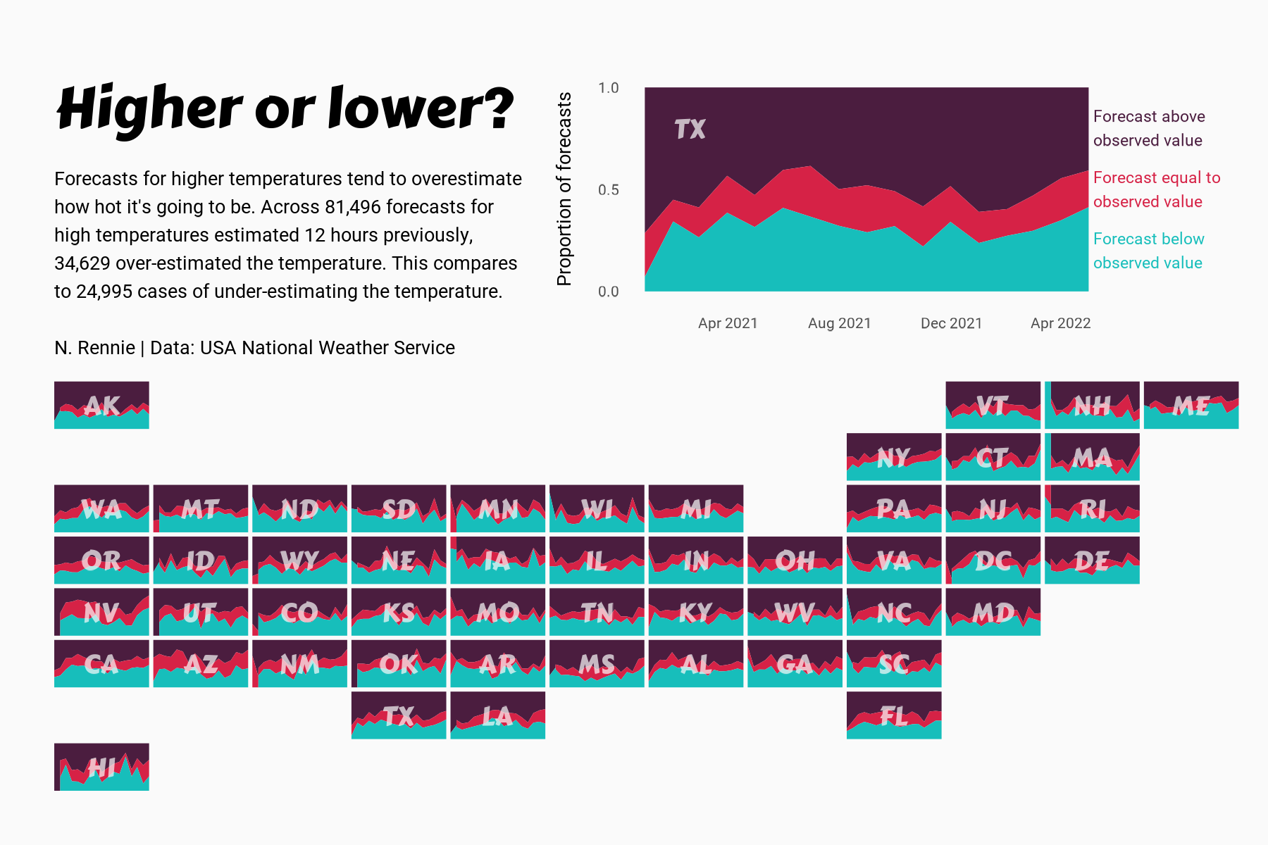
 View projectThis chart visualises the accuracy of high temperature forecasts made by the USA National Weather Service between January 2021 and June 2022, within a 12 hour window. Proportional area charts show...
 -
 View projectThe island of Hawaii (also known as Hawaii's "Big Island") is made of five volcanoes. This map visualizes these volcanoes in a simple, straightforward, and stylized way — the volcanic peak (center...
 -
 View projectWe are sensorial creatures who inhabit the world surrounded by sensory data (Serres, 2008); also, we experience the world by continually engaging all the senses (Le, 2017). In such a context, we...
 -
 View project“World Heritage in Danger 2023” is an information design and data visualization project with an aim to raise awareness of decaying beauty in our world with a skeptical overtone. The data...
 -
 View projectThis publication explores plastic bag usage in the UK, considering the juxtaposition of perspectives from the supermarkets and in turn the consumers. The data presented visualises: The number of...
 -
 View projectCurbing global warming, halting the loss of biodiversity, and building a just and equitable economy are among the world’s most pressing needs. To track progress and reveal systemic obstacles to...